
Historical Maps
Old maps help us to see a part of our town's history. The maps below are dated 1874. Each of these maps at full-size will take a minute or two to load on your computer. Many family names can be seen on the maps as well as locations of some businesses. Note that the scale used on the larger maps is "20 rods to an inch." (20 rods = 330 feet)
This building is on the Bakerville map. It is located on the lower left of the map and is labled "Mill." The map shows how close the building is to the road.
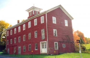
Photo by Maria Moore.
The barn used to stand on Route 202 in Bakerville.
New Hartford Maps
The links below will take you to old maps on the web. For those who are interested in maps or history we will continue to add links as we find them. If you know of a site that has interesting, historic maps related to New Hartford, please send the information to the Webmaster.
Please note that the maps can take quite a while to download, depending upon your connection speed.
UNH DIMOND LIBRARY
Documents Department & Data Center
Historic USGS Maps of New England
7.5 Minute Series
Year: 1951
Connecticut Maps